
History of Richmond & Wayne County, Indiana
First Settlers
Founded by North Carolina Quakers who settled along the Whitewater River in 1806, Richmond capitalized on the location as a trading and transportation center and became the county seat of Wayne county in 1873.
The first permanent settlers on the present site of Richmond were John Smith and Jeremiah Cox, two North Carolina Quakers who arrived in 1806. They came here by way of Quaker Settlements in Western Ohio.
John Smith, who opened the first general store, entered land on the eastern bluff of the Whitewater River, south of present Main Street. He erected a pole log cabin near South Third and B Streets.
Jeremiah Cox, who built the first grist mill, bought two quarter sections of land north of the present Main Street. Four acres had been cleared and planted in corn.
David Hoover and several other land seekers traced a section line from a point eight miles north of Dayton, Ohio to the banks of the Whitewater River early in 1806. The Hoovers took up land north of town.
However, these settlers were not the first ones who had acquired land in the present Wayne County. Richard Rue and George Holman, along with Joseph Cox and Thomas McCoy and their families, had settled in Elkhorn and Abington areas of the county in 1805.
Greenville Treaty
When Smith and Cox acquired land on the site of Richmond, the only part of Indiana Territory open for settlement was east of the old Greenville Treaty boundary. This line ran from Fort Recovery, Ohio, in a southwesterly direction to a point on the Ohio River, opposite the mouth of the Kentucky River. It was established in 1795 by General (Mad) Anthony Wayne in a treaty with the Indians at Greenville. It crosses U.S. 40 about two miles west of Richmond. All land west of this boundary belonged to the Indians when Smith and Cox settled on the eastern bluff of the East Fork of the Whitewater River in 1806.
The Indians claimed the Whitewater Valley as their hunting and fishing ground "from time immemorial," in the words of Chief Turtle. In 1809 Governor Harrison signed a treaty with the Indians which opened for settlement a 12-mile strip, paralleling the Greenville boundary line. This was called the Twelve Mile Purchase. The line crosses U.S. 40 in western Cambridge City.
First Streets Laid Out
John Smith, owner of the land south of Main Street, came to the conclusion in 1816 that there should be a system and plan to govern the location of the houses and streets in the settlement. For that reason, he proposed to his neighbor, Jeremiah Cox, whose farm adjoined his to the north, that they lay out the town site. Jeremiah Cox refused to enter into the building project so John Smith hired David Hoover to survey lots on Front (now Fourth Street) and Pearl (now Fifth Street) from present South E Street to Main Street.
Although Cox shied away from promoting the town, he nevertheless sold small parcels of land and lots to settlers. Among the sales was one to his brother-in-law, Robert Morrisson, who acquired the northwest corner of Main and Ft. Wayne Avenue. Convinced, finally, that a town would inevitable be organized on the eastern bluff of the Whitewater River, Cox joined Smith in 1818 in the town project.
Richmond Named and Incorporated
In the meantime, Smith had named his settlement Smithville. So Cox, using part of his name, Jeremiah, had called his collection of houses Jericho. Both towns settled East of the river so there was no need to build a bridge. Settlers did not like either name so they accepted Richmond, suggested by David Hoover, as a compromise.
On September 1, 1818, the twenty-four qualified voters of the settlement met in a house on the northeast corner of Main and Ft. Wayne Avenue and voted to incorporate the town.
Better Transportation Routes Encourage Growth
In the summer of 1807 they build a road to Eaton, Ohio to give them a direct connection with the "Wayne Trace," the old military road built by General (Mad) Anthony Wayne from Fort Washington (Cincinnati) to Greenville in his Indiana campaigns. Elkhorn settlers built a road between Elkhorn and Salisbury, the county seat. The only two roads entering Indianapolis in 1826 were the one from Madison, the other from Centerville. In 1817 settlers, living north of town, cut the "Quaker Trace" to Fort Wayne to give them a trade outlet there.
The first store was opened by John Smith in a buckeye log cabin near his home on South Second and B Streets. His goods were transported to the store on pack horses. Later, wagoners made the trip from Cincinnati to Richmond in six to ten days over roads that were almost impassable. Within twenty years after the arrival of the first settlers on the site of Richmond, various trades and forms of business and industry were well established. It was no longer necessary for settlers to travel long distances to obtain the essentials and necessities of life.
Richmond's growing pains started after Indians stopped their petty raids. From 1815 on, the eastern Indiana frontier began to bustle. Richmond's sustained growth as a trading center permitted it to out distance other southeastern Indiana towns like Madison, Lawrenceburg, Rising Sun, Vevay, Brookville and others.
Iron works began to make steel plows. Gaar, Scott & Co. became the nation's largest producer of boilers and steam engines. Starr Piano became the respected maker of musical instruments. Gennett Recording attracted top musicians to its sound studios.
The "mix" between farm activity and factory production led Richmond into a leadership role in East Central Indiana.
First Post Office Established
The first post office in Richmond was established in 1818 with Robert Morrisson appointed as postmaster. In 1829 when he was succeeded by Daniel Reid. Mails arrived every two weeks, provided the carrier was not delayed by rain or snow.
The post office was opened in a frame building at the corner of Main and Front (4th Street) and later moved to the northwest corner of Main and Pearl (5th Street). For many years the post office was situated at the southwest corner of North 9th and A streets, but early in the 1970's a new post office was built at the corner of North 5th and A Streets. The first free delivery of mail was established in Richmond on January 1, 1881 and rural route delivery began in 1897.
National Road Surveyed
The National Road, now U.S. 40, was surveyed to Richmond in 1827. A covered bridge across the Whitewater River at the foot of Main Street was completed in 1836. Other means of transportation were explored with the Whitewater Canal.
Second Oldest Newspaper in the State
The first issue of the Richmond Palladium was printed January 1, 1831, and therewith became the founder of a journalistic enterprise that 150 years later had the unusual distinction of being the second oldest newspaper in Indiana from the standpoint of continuous publication. In 1907 it acquired the Sun-Telegram and consolidated it with the Palladium. Many years later it also acquired the Richmond-Item and now carries the name of the Palladium-Item.
Two other weekly newspapers were started before 1831. They were the Richmond Weekly Intelligencer (1821-1824) and the Public Ledger (1824-1828). Another newspaper started before 1850 was the Jeffersonian (1836-1864). Before the Palladium became a daily, several other newspapers were started. These included the Daily Independent (1873-1879), the Daily Free Press (1874-1879), and the Laurel Wreath (1875-1878). None of these are in existence today except for the Palladium-Item.
Bank Established
The first bank in Richmond was a branch of the State Bank of Indiana which opened in December of 1834 on the northeast corner of Main and Pearl (5th Street) and was in operation until 1865. The First National Bank was established in 1863 and is the oldest national bank in the state of Indiana and the sixth oldest national bank in the United States.
Library Founded
Morrisson-Reeves Library was founded by Robert Morrisson, who came from North Carolina to Wayne County in 1810. Mr. Morrisson's name is intimately associated with the history of Richmond and, being one its earliest merchants, he accumulated a large estate. The crowning act of his life was the founding of the library in July 30, 1864 at a cost of $20,000 which he transferred as a gift to Wayne township. The old building, having outlived its usefulness, was torn down in the summer of 1975 and a new library erected just south of the old location on North Sixth and A Streets.Education Considered Important
 Earlham College, which has an enrollment of about 1,200 is known as a liberal arts school. It was founded by the Society of Friends in 1847. Many of its graduates have attained fame as scientists and educators. Among these is Wendell Stanley, a famed scientist. A science building on campus bears his name.
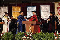
Indiana University East is the outgrowth of a cooperative venture involving Earlham College, Indiana University, and private citizens in Wayne County. The school originally was established in 1946 at Earlham College, through a cooperative arrangement, to provide credit and non-credit courses in the area. It was called the Earlham College-Indiana University Extension Center until 1967 when Purdue University and Ball State University joined the venture.
Due to the Center's growing enrollment through the years, Richmond citizens in 1969 formed the Eastern Indiana Community College to raise funds toward the cost of a new site and construction of a campus in Richmond. Ground was broken for the new home in October 1972 on 230 acres near the intersection of U.S. 27 and Interstate 70 on the north side of Richmond. The first building was completed late in the fall of 1974 and occupied in January 1975.
As enrollment gains, Indiana University East offers advanced academic and vocational opportunities and a wide rage of economic and cultural advantages to students of the surrounding area. A $1 million Indiana Vocational Technical College (Ivy Tech Community College) opened in 1976 as a facility to train office, hospital and factory workers. The addition of Earlham School of Religion and Bethany Theological Seminary makes Richmond "The City of Colleges".
Transportation
In addition to the National Road being a main artery through Wayne County; Richmond also became a hub for many railroads. The first locomotive entered Richmond in March 1853. A railroad was established to New Castle in 1854 which eventually led to Chicago. The railroad to Winchester was started in 1870 and two years later it was extended to Fort Wayne. Interurban lines passed through Richmond between Dayton, Ohio and Indianapolis, Indiana in the early 1900's but were discontinued in the 1940's. Construction of an airport south of the city marked the last step in the evolution of the transportation system.
Richmond Becomes the "Rose City"
 Richmond's floral industry began in 1881 when E.G. Hill and his father, Joseph, began a general floral catalogue business on the south side of East Main Street, between 20th and 21st Streets. In 1887, following the death of their father, E. G. Hill and his sister Sarah Hill moved the business to the edge of what is now Glen Miller Park.
The greenhouses in Richmond had nearly 34 acres under glass. All featured production of roses, followed by mums, orchids, and other flowers. Hills' Floral Group continued as the recognized leader in the floral industry; hybridizing, growing, distributing, importing, and wholesaling flowers and floral products throughout the United States until 2007.
Research and development was a strong part of the intricate processes at Hill Floral Group. The odds are about 2,000,000 to 1 against developing a rose superior to one already grown today. More than $100,000 annually was budgeted for research and development. Hills Floral Group introduced multiple varieties including, Classy, a long lived large, romantic red and Ginger Hill, a delicate yet robust and braggart blush white. The Richmond Rose Festival honored the rose industry and was a popular summer event.
Glen Miller Park NOT Named for Band Leader
Glen Miller Park, the largest of several parks in the Richmond Park and Recreation system, has 194 acres of beautiful wooded area. It has fresh spring water flowing from several different locations in the park and wild flowers growing abundantly. This land was purchased by the City of Richmond in 1885 at the, then so fabulous, price of $35,000.00. Colonel John Miller was the owner and from his name plus the natural topography of the area came the name, Glen Miller. This park formerly had a 9 hole golf course available to the general public, now public putting greens and a walking course, tennis courts, horseshoe courts, a bandstand and open air theater, several shelter houses and over 600 picnic tables and numerous grills throughout the park.
A small lake is located in the center of the park and once a year it is stocked and a children's fishing rodeo is held. At the 22nd Street entrance to the park stands a tall statue of the Madonna of the Trail, which is one of several along the old National Road (U.S. 40). It was erected by the National Society of Daughters of the American Revolution (DAR) as a memorial to pioneer mothers of the covered wagon days. It carries the inscription, "A nation's highway once a wilderness trail over which hardy pioneers made their perilous way seeking new homes in the dense forests of the great northwest." The first toll gate in Indiana stood near this site on the National Road.
The newest of our parks is Middlefork Reservoir, which encompasses a 177-acre lake where fishing and boating are popular in season. The lake is constructed so a second stage can be created by adding flood gates to increase the acreage of the water to 271 acres. The Richmond Sailing Club has races here.
Hospital Established
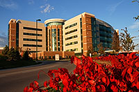 Land for the site of Reid Memorial Hospital was purchased by Daniel G. Reid from John F. Miller and located just north of the city in the suburb of Spring Grove. After Mr. Miller sold the land to the City for Glen Miller Park, he purchased the ground in Spring Grove and established his home there. This home later became the site for Reid Memorial Hospital. The cornerstone was laid in 1904.
The hospital was a gift to the area from Daniel G. Reid and was built as a memorial to his wife and son. The first unit was dedicated July 27, 1905. During the years there have been several changes and additions, including an expansion done in 1975 at at cost of approximately $15 1/2 million, which included the eight story Leeds Tower. Major benefactors were Walter E. Wallace and Rudolph and Florence Leeds.
In 2004 the hospital broke ground for an entirely new facility at 1100 Reid Parkway and it was completed in 2008.
Arboretum Preserves Natural History
Hayes Arboretum was started by Stanley W. Hayes and was a 30-acre area of forest just east of the city of Richmond when he acquired it. No timber cutting or grazing had been permitted in the half-century previous to the purchase in 1917. The enormous beech trees, which are now between 200 and 250 years old, have been undisturbed for the past century. As Mr. Hayes wished to preserve the Arboretum for scientific study and public enjoyment, he created the non-profit Hayes Research Foundation before his death in 1963 and it is now used for educational, scientific, recreational and community participation.
The Arboretum Garden was started about 1933 by Mr. Hayes with the help of a state forester and noted botanist. It has 147 species of trees and shrubs native to this region of Wayne and surrounding counties. Because it displays only species that grow in this area, the Hayes Arboretum is called a regional Arboretum. In the southeast corner is an eight acre tract containing species which made up what was once known as the greatest hardwood forest in the nation. A 130 year old former dairy barn has been made into a center for educational activities. The horse stalls have become classrooms, the calf pen a nature library and the hay loft a display area. Nature trails have been provided for walks deep into the woodland and 3 1/2 mile auto tour route displays 50 different trees, each identified by name tag.
The Arboretum is on land that has been covered by glaciers a number of times during the last several hundreds of thousand of years. Geologic evidence suggests strongly that the last of these glaciers advanced from a northerly direction about 30,000 years ago and melted away from the Richmond area 15,000 years ago, more or less.
Pioneer Heritage Preserved
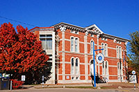
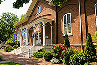 The Wayne County Historical Museum is operated for the benefit of the people by the Wayne county, Indiana Historical Society, a non-profit educational organization. It was opened in the historic Hicksite Friends Meeting House on North A Street, August 16, 1929. The Meeting House, built in 1864 along the simple lines of a Quaker place of worship, was given to the Historical Society by the Whitewater Monthly Meeting of Friends, "in memory of those whose lives so worthily exemplified the principles of the Society of Friends." The Historical Society purchased the real estate from the Monthly Meeting in 1930.
Among the attractions are the Solomon Dickerson log house, built in 1823, which was moved from Fort Wayne Avenue as a community project to the Museum grounds in 1967. Also on the grounds are a recreated bakery and an early newspaper office. The Museum houses many of the cars produced in the area, along with an airplane. The main focus of the collection is Wayne County's pioneer heritage.
The Wayne County Historical Museum is also known as the Julia Meek Gaar Museum since it was largely through her efforts and donated collections from her around-the-world travels that it was established. Among the more eclectic items included in her collections are a Samurai warrior's uniform and one of Wayne County's two Egyptian mummies (the second can be found at the Joseph Moore Museum on the Earlham Campus). The Wayne County Historical Museum is regarded by many as one of the outstanding local museums of the country.
The City Rebuilds
On April 6, 1968, a disastrous explosion and fire occurred in the downtown area of Richmond. Several blocks of downtown were destroyed or damaged. Forty-one persons were killed and more than one-hundred fifty injured. The explosion propelled the redevelopment of the downtown, with a four-block mall as a center of attraction. The Downtown Promenade was dedicated in 1972 and national landscapers singled it out for an award. A fifth block was added in 1978. In 2008, on the 40th anniversary, a film documentary was released. It is called 1:47 - which was the time the explosion occurred.
In the early 1990's a re-evaluation of the needs of local citizens and vendors downtown was taken under consideration. The desire for more parking and easier access to merchants in the middle of the blocks caused the city to reopen the street to traffic in 1997.
The Uptown Project kept a landscaped feel to the area and used Starr bricks - manufactured in Richmond - as an accent.
Today....and Tomorrow
Today Richmond is a city of approximately 40,000 and is often referred to as the Eastern Gateway to Indiana. It's location on the border of Indiana and Ohio puts it within easy driving distance of Dayton, Ohio (45 minutes) and Indianapolis, Indiana (60 minutes), in addition to being able to take advantage of the cultural offerings of Cincinnati, Columbus, Detroit, and Chicago - all within a 5 hour drive or less.
It has a varied industrial background, an active Economic Development Corporation, and shovel-ready land in local Industrial Parks. It's location near Interstate 70, between Interstate 75 and Interstate 65 continue to offer businesses the advantages of location that the Wayne County settlers enjoyed.
Richmond serves as the retail center for several counties, offering everything from upscale department stores, to national chains, to unique one-of-a -kind boutiques. It is the center of the antique mecca known as Antique Alley.
Education of its children is up most on the minds of the citizens, who have access to excellent public and private schools, in addition to many institutions of higher education.
The future for the Richmond/Wayne County area looks very bright indeed!
Cambridge City
 Founded in 1836, the town has always relied upon its location on the National Road, though for awhile, the Whitewater Canal offered new commercial possibilities. Here, Single "G", holder of two world records, achieved lasting fame in the world of horse racing, just as the noted Overbeck sisters quietly left their mark in the field of creative ceramics.
Point of Interest:
The Huddleston House - a stagecoach stop completed in 1839, isolated at Mt. Auburn and owned by Historic Landmarks Foundation of Indiana.
Centerville
 Owing to its Central location in Wayne county, Centerville was selected as the county seat in 1818. With the building of the National Road in 1829, the town flourished commercially as well as politically. In addition to a rich architectural heritage that resulted in the naming of the entire town to the National Registry of Historic Places, significant contributions have been made in the realm of the humanities.
By 1870 Richmond had surpassed Centerville in population and business. As a railroad center, Richmond offered greater advantages to farmers, merchants, and traders. The population of Wayne township alone was equal to the balance of the county and paying a large part of the taxes, so a cry went up for the county court house to be moved to Richmond. After much bitterness between members of the two towns, the court house was declared finally fixed in Richmond on March 8, 1873.
Point of Interest:
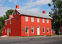
The Mansion House - an 1840's tavern - now housing collections of early American and Victorian antiques, and serving as headquarters of Historic Centerville, Inc.
Fountain City
 The town was known as Newport when some 2,000 fugitive slaves were aided in their escape to Canada through the united efforts of the members of this small Quaker community.
Point of Interest:
The Levi Coffin House - "Grand Central Station, of the Underground Railroad", has long been recognized as a Registered National Historic Landmark and was restored by the Levi Coffin House Association, and Wayne County Historical Society.
Hagerstown
 Known as the upper terminal of the Whitewater Canal to Cincinnati in the 1840's, the town in now headquarters for Historic Hagerstown, Inc. The generous gift by Perfect Circle Corporation, of one of the Teetor family estates, will assure future funding of historical projects.
Point of Interest:
Conder Home on Main Street
Back to Did You Know...? | Back to Top
Information gathered from material provided by the Wayne County Area Chamber of Commerce.


Did You Know?
Follow Us
![]()
![]()
![]()
![]()
Contact Us
| Email: | info@waynet.org |
| Phone: | 765.939.0857 |
| Mail: | 50 North 5th St. Richmond, IN 47374 |
| Director: | Board of Directors |
Stay in Touch
Sign up for WayNet News
- our e-newsletter.