
Nature Trail Guide: Whitewater Gorge Park
The trail is 3 1/2 mils long from Test Road to Thistlethwaite Falls. It takes roughly 2 hours to walk the length of the trail and back at a moderate pace. There are 9 bridges on the trail and 8 sets of stairs. Parking is available at Springwood Park, Weir Dam and the Test Road entrance. The numbers below coordinate with the numbers on this map.
1 - Thistlethwaite Falls
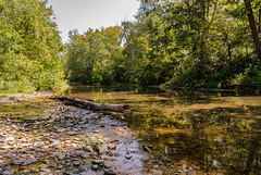
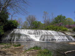 Thistlethwaite Falls is one remnant of an ancient waterfall which has been migrating upstream for thousands of years, deepening the Gorge as it went. The Niagara Gorge was formed in a similar manner by the backward movement of Niagara Falls. A dozen Potawatami Indiana teepees were seen near Thistlethwaite Falls by one of the first white settlers. Later, a mill was built nearby and the falls became a popular picnic spot for early residents of Richmond.
2 - Bird Sanctuary
 About twenty acres of flood plain and wooded hillside owned by Friends United Meeting are being managed as a bird sanctuary here. The Gorge presents favorable nesting conditions for about fifty species of native birds - from house wren to green heron. How many will you see? How many more will you hear?
3 - Vertical Cliffs
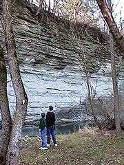 North and south of where Bridge Avenue crosses the river, the bedrock of limestone and shale is exposed in nearly vertical cliffs. These layers of rock ere deposited by an ancient sea about 450 million years ago and contain one of the world's best fossil records of the primitive animals that lived in that period. So valuable are the examples of rock strata exposed here and elsewhere in the Gorge that "Richmond Group" and "Whitewater Formation" are recognized categories in geologists' system of classification
4 - Happy Hollow
This narrow portion of the Gorge upstream of the confluence of the two forks has been nicknamed "Happy Hollow" for a hundred years. Some old-timers say the name stems from happy Saturday-night singing of the Irish families who once lived here.
5 - Weir Dam
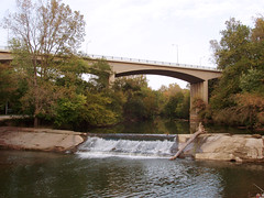 This concrete dam used to divert cooling water to a city-owned electric power plant which occupied the flat flood plain north of the Main Street bridge. The first electric generators were built there in 1894 by private interests. The city-owned Johnson Street Station went out of service in 1954, replaced by a larger plant south of town.
6 - Flour Mill
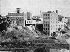 On this spot in 1864 a flour mill was established which later became the Richmond Roller Mills. It ran on water power, then steam, and its seven-story building dwarfed the Gorge wall into which it was built. The mill went out of business early in this century and a shattered foundation on the steep slope is all that remains of this once-prosperous enterprise.
7 - First Public Utility
 This brick building (now demolished) located on the edge of the Gorge was erected in 1858 to house Richmond's first public utility. The Richmond Gas Light and Coke Company produced from coal with coke as a by-product, was a great improvement over the sperm oil lamps and candles used previously for lighting.
8 - Wayne County Courthouse
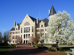 You can see the monumental Wayne County Courthouse from many points on the trail. Designed by a Cincinnati architect in the popular Romanesque revival style, it took six hundred wagon loads of Bedford Oolitic limestone to build it. This courthouse, completed in 1893, was the sixth built in Wayne County.
9 - National Road Bridge
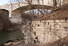 Just south of the towering Main Street bridge on the east side of the river, you can see old stones built into a mound of earth. They are ruins of the National Road Bridge, Richmond's first bridge over the Whitewater River. In use from 1834 to 1895, it was the first covered bridge in Indiana, a magnificent span resting on stone piers thirty feet above the water. The National Road bridge boasted seven wooden arches, two teamways, and two walkways. Imagine the relief of settlers traveling west on the Cumberland Road (later called the National Road) when they found they would not have to ford the river and haul their wagons up the western bluff along a gully.
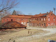
10 - Starr Piano Company
 The two-story brick building across the river is the first one built by the Starr Piano Company in 1872. Until 1949, the Starr factory produced upright, grand, and player pianos in a sprawling complex which was known as "Banjo Valley". The Whitewater River powered the factory until 1903. In its heyday, Starr had more than a thousand men building twenty thousand pianos per year in thirty-one buildings. Award-winning Starr pianos were recognized around the world for their excellence.
11 - Gennett Recording Studio
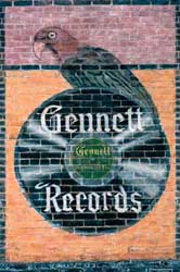 Did you know that Hoagy Carmichael, Bix Beiderbecke, Jelly Roll Morton, Louis Armstrong, Gene Autry, even William Jennings Bryan all visited the Gorge in years gone by? These luminaries and many others made blues, jazz, hillbilly, spoken and other records at the Gennett Recording Studio, which was a subsidiary of Starr Piano, between 1915 and 1934. In the mid-1920's, Gennett was producing three million records per year in the Gorge, but the Great Depression silenced this musical trailblazer.
12 - Fording the Whitewater
 Before the National Road Bridge was built, Conestoga wagons forded the Whitewater at a point about halfway between the present day "G" Street bridge and the surviving six-story Starr Piano building. The river was shallow there and the bottom was covered with hard, flat stones.
13 - Flood Plain
 The wide, flat expanse of flood plain under the "G" Street bridge is covered by many towering sycamores and numerous other trees and shrubs. A century ago this same land was a tidy farmstead with a home, outbuildings, grist mill, but few trees. Today the land is largely owned by the Richmond Water Works which pumps groundwater from deep deposits of sand and gravel lying beneath it.
14 - Quarries
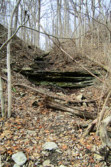 The slabby nature of the bedrock (alternating layers of shale and limestone) is easy to see in many gullies and outcrops in the walls of the Gorge. The shale breaks down into clay and the limestone falls out in flat chunks well suited for foundations, walls, and chimneys. This accounts for the numerous quarries in the Gorge in the nineteenth century. An 1874 atlas shows a large quarry east of the river at the location indicated.
15 - Canopy Trees
 Soon after white settlers arrived, they began stripping the Gorge of the massive canopy trees that covered its slopes - beech, sugar maple, tulip tree, white ash, elm, walnut, black cherry, hackberry, oak, and hickory. Most of these species are now making a comeback, but American beech, a very slow-growing tree with smooth, light-gray bark, is still rare. There is one young beech, about 15 feet tall, just east of the upper trail about halfway between Test Road and "G" Street. Will you see it when you pass?
16 - Test Woolen Mill
 The decaying foundation of stone and brick near the trail is all that remains of the Test Woolen Mill that operated here from 1855 until 1900. It consisted of a three-story mill building with a large overshot mill wheel and a separate one-story dye house, both torn down in 1904. In the 1800's many mills were built along the Whitewater, a swiftly-flowing stream that falls six to ten feet per mile toward the Ohio River basin. The river was dammed to create a millpond and water was transported from the millpond to the mill in a ditch called a millrace. Not far up the trail you should look for a long narrow depression in the earth that was part of the millrace for the Test Woolen Mill.
If the Whitewater Gorge contains many relics that remind us of the past, it is also a showcase for natural phenomena that span past, present, and future; steep valley walls and dense green foliage in summer, slightly lower temperatures caused by cool air settling down into the Gorge, the trill of unseen birds, and the sound of the river shaping and reshaping the flood plain.
Development of the Whitewater Gorge Park will help restore the Gorge to a place of honor in the heart of Richmond and preserve the beauty of the Gorge for future generations. Please Do Your Part! As you walk on the trail enjoying the natural and historic features of the Gorge, do not damage or pick plants and please dispose of trash properly.
- Whitewater Gorge Park
- A Fossil Hunter's Guide to Whitewater Gorge Park
- Geology - The Richmond Group
- Map - Whitewater River Valley Gorge Park Trail System
- Parking & Trail Information - Whitewater River Valley Gorge Park
- Gorge Trail Map (paved section) on Community Maps
Thanks to the Richmond Parks and Recreations department for allowing us to share the text from the Whitewater Park Trail Guide
Special thanks to Brian Jones of Photo ReStore for the use of the enhanced Gennett logo.
![]()
![]()
![]()
![]()


|
|
|
|
|
|


Featured Member
Did You Know?
Follow Us
![]()
![]()
![]()
![]()
Contact Us
| Email: | info@waynet.org |
| Phone: | 765.939.0857 |
| Mail: | 50 North 5th St. Richmond, IN 47374 |
| Director: | Board of Directors |
Stay in Touch
Sign up for WayNet News
- our e-newsletter.
